
South America
extends from north of the equator almost to Antarctica. This gives South America a large area in the tropics, through more temperate zones, and way far south to very cold parts of southern Chile and Argentina. South America extends much farther south than any other inhabited continent. South America has the Pacific Ocean on the west, the Atlantic Ocean on the east, and the Caribbean Sea to the north east. The Andes Mountains run along the west coast of the continent, head waters for the Amazon, the largest river (by volume) in the world, which flows to the Atlantic Ocean. The Atacama Desert, on the west side of the Andes Mountains, is the driest desert on earth. The highest waterfall in the world is Angel Falls in Venezuela. South America has a breath-taking diversity of landscape and of species of plants and animals. Brazil constitutes roughly half of South America, both by land area and population.Brazil was a colony of Portugal, while most of the rest of the countries of South America were colonies of Spain. This is reflected in the national languages, where Portuguese is spoken in Brazil, and Spanish in most of the rest of South America. The three small countries on the northern coast speak Guyana (English); Suriname (Dutch); and French Guiana (French). In addition, there are many native languages spoken all over South America.
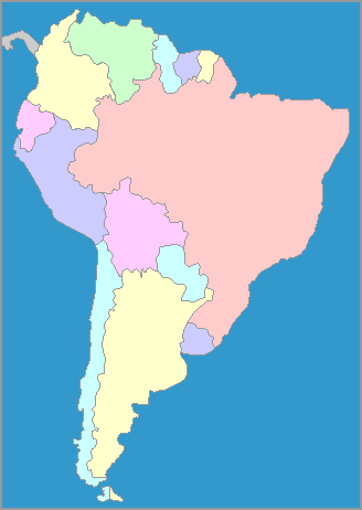
The map of South America shows the countries and their capitals, as well as the bodies of water around them. South America is the southern continent of the Americas. Most of South America is in the Southern hemisphere, as the equator runs through the aptly-named Ecuador, as well as going through the countries of Colombia and Brazil. Brazil is approximately half of the land area of South America, and of the population. The southern-most tip of South America, belonging to both Chile and Argentina, comes much closer to Antarctica than any other continent. This part of South America, as might be expected, is cold and stormy, and ships traditionally have had a dangerous passage through the Strait of Magellan, a sea passage through the tip of South America between the Atlantic and Pacific Oceans.
