
|
|
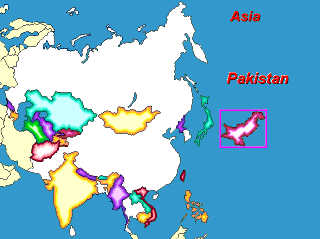
Learn the geography of Asia with a free educational map puzzle. The countries of Asia and their capitals. |
 |
Asia Map PuzzleLearn the countries of Asia and their capitals with this fun and educational puzzle game. How fast can you put all of the countries in the right places?
Free! Play Asia Map Puzzle online |
||
More
Map Puzzles!
Find more FREE Educational Software
at the
|
 Our
world has become an increasingly complicated place. We
don't know what country will be on the news tonight and
how events there will concern us. It is important to know
the world and to know about the world before the world
comes to us. Consider how much geography the average 16
year old knows and remember they may vote in the next
presidential election. Our
world has become an increasingly complicated place. We
don't know what country will be on the news tonight and
how events there will concern us. It is important to know
the world and to know about the world before the world
comes to us. Consider how much geography the average 16
year old knows and remember they may vote in the next
presidential election.The heart of geography, and even the source of its name, is the map - a picture of the world which organizes our understanding of places. Manipulating a map, assembling it, is the best way to learn where the different countries are and what other countries they are near to or far way from. This forms a lasting image and understanding. It is hard to know much of a foreign place without knowing where it is. The map is a framework that brings other knowledge together and makes the world understandable. Geography is spatial – so why not learn it spatially? Download and play the Asia Map Puzzle game. Put in the countries with their borders shown on the background to learn quickly. Try it without the national borders to test your knowledge. Learn the capitals before you hear about them on the evening news. Play for your fastest time or just for fun. Better than a wooden map puzzle: more learning and more fun. With this game you can’t lose Mongolia under the couch.
|
||
 |
You might also be interested
in: Interactive Map of Asia |
|
|